FAQs–General
What have the Big Marine Lake levels been historically?
Why was water flowing north into BML in Spring, 2022?
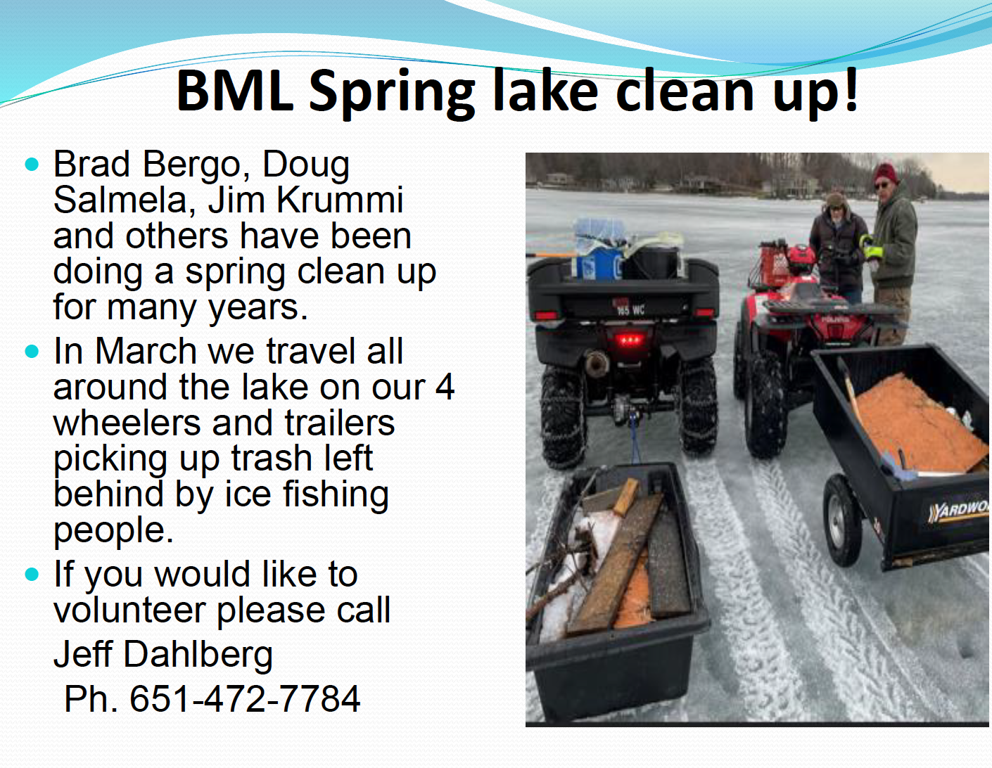
What is being done to help keep BML free of trash in the winter and spring?
Is a DNR permit required to remove ice ridges which may form each winter?
How many members has the BMLA had in the years since founding?
What can be done about shoreline erosion?
Why are there occasional spring die-offs of fish in BML?
How much volunteer time is put in by the BMLA each year?
What happened with the DNR plan to stock muskies in BML?
What precautions should be taken regarding herbicide treated waters?
Where can information be found about regulations for building on shoreline property?
What have the Big Marine Lake levels been historically?
The DNR has tracked lake levels on Big Marine Lake since 1961. The water level is monitored and recorded every two weeks. Following are two graphs of the recordings:


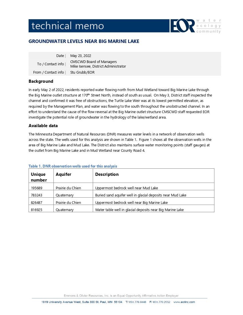
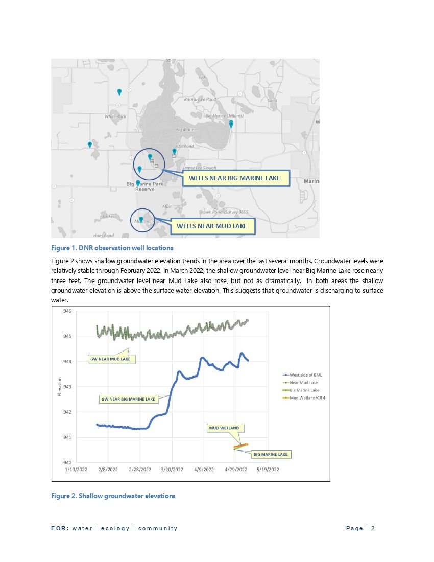
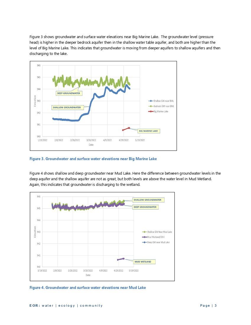
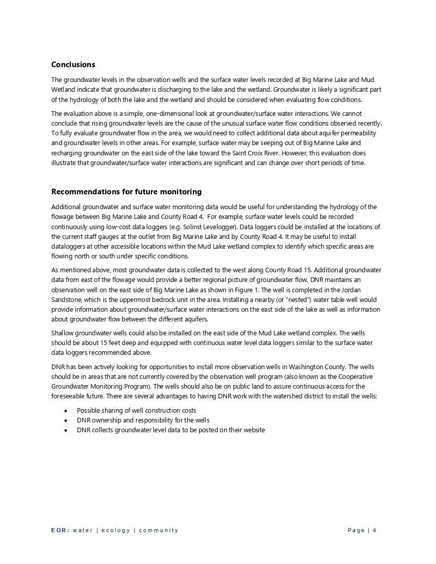
Why was water flowing north into BML in Spring, 2022?
When the ice first went out in 2022, the water level was such that there was no outflow. However, in May, there was a time when water was flowing south to north through the weir at County Road 4. Following are a letter, a report, and a chart giving some details on the situation. The ultimate best guess conclusion was that there was a ground water swell in the area south of BML.
From: Mike Isensee
Sent: Monday, May 2, 2022 12:43 PM
To: Jeff Dahlberg <jld1dahlberg@gmail.com>
Cc: Blehert, Mike <mblehert@q.com>; Vavoulis Tony <tony@ksarealestate.com>; Burton Rich <richardburtonmn@gmail.com>; Downing Matt <mdowning@mnwcd.org>; michael white <mew4906@outlook.com>; WADE A. Johnson <wajohnson23@gmail.com>; Scollan, Daniel (DNR) <daniel.scollan@state.mn.us>
Subject: Big Marine Lake Outlet Update
Hello Jeff,
Thank you for all the phone call notifying us that tailwater is flowing into Big Marine Lake through the outlet weir. I also returned Dick Bohr’s phone call this morning. Here is an update on our actions and findings:
After receiving some concerns about water flowing from the wetland into Big Marine Lake Manager Mike White toured all locations crossing locations on Thursday, April 28th and found “Check out the system, Kelly Farm water crossings and other check points down to the railroad tunnel. Found no blockage or bever dams on the whole system.”
As part of the normal water level monitoring program, the first level of the year was taken by the Washington Conservation District that same day: “We surveyed the outlet on Thursday 4/28 and found the elevation to be 940.54 on the Big Marine side and 940.63 on the Mud Wetland side.”
The Turtle Lake Weir is still in its winter flow condition (all 4-inch stop logs removed). Per the 2017 Turtle Lake Weir Management Plan 4” logs will not be installed until the “tail-water elevation (south side of County Road 4) is below the crest of the Big Marine Lake Outlet Structure by more than 0.2 feet” which it is not.
This morning I notified the Washington Conservation District that we need another inspection this week from their maintenance crew. I am waiting to hear back on when the crew is available- hopefully tomorrow but definitely by Thursday at the latest. They will create a photo log of each crossing point through Kelly Farms and remove any obstructions. I will distribute the photos to all of you before the end of the week.
One additional note: On page 1 of the Turtle Lake Weir Management Plan it states ” 1. Agreements made with the Minnesota Department of Natural Resources (MNDNR) call for the water surface elevation on the south side of County Road 4 to be targeted at an elevation of 940.6 (0.2-ft below the Big Marine Outlet Structure Crest).” So it appears we are within the targeted operational range of the plan.
Please feel free to pass this along to others so they are aware of the current actions and status.
Thank you,
Mike
Following is a report on the groundwater issue.
BMLA Activities and Actions

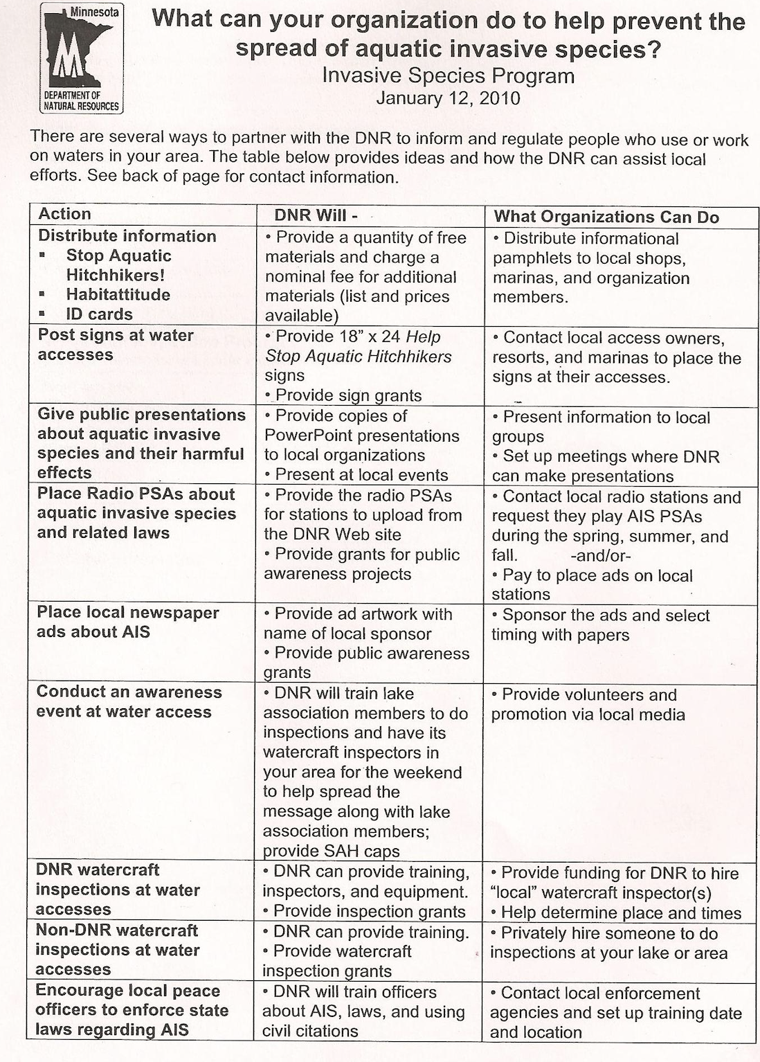
Here are actions suggested by the MN DNR:
What is being done to help keep BML free of trash in the winter and spring?
In addition to the spring lake cleanup, the Vets Camp has policy outlined in their written Campground Rules which are given to visitors upon check-in. All temporary visitors must check in. At check-in, visitors are informed of the ice fishing rules. The VC polices the ice regularly and after all ice fishing houses are removed from the lake at the end of the ice fishing season. The camp has video cameras which monitor and record 24/7 the marina area (and ice fishing house area at the VC in the winter). The VC provides as many as 2 portable toilets on the ice and 2 on shore as needed. In addition, there are 3 portable toilets in the camp itself and many veterans bring their own. The policy regarding the ice is considered to be covered by “Site Maintenance” rules included in the Campground Rules document. The “Site” includes the lake (and lake ice) in front of the campground. The VC manager and the VC Board want to be good stewards and are good stewards of the entire site.
Other ice fishing people besides those at the VC may foul the ice. Also, in summer, boaters using the Park Reserve area on the west shore of the main lake no doubt leave litter. The fact that the VC provides toilet facilities on the ice and in the camp could mean a lower % of defiling there than in other locations on BML. It is fortunate the up to 30 or so ice fishing houses put on the ice (including the two VC provided houses) at the VC are there where there is access to toilet facilities and are monitored by VC personnel for littering. They could be elsewhere on the lake and subject totally to the whims of their owners.
The Minnesota Legislature passed a litter-on-ice law in 2023. For more information on this law, refer to an article in the December 27, 2023 Country Messenger. https://www.countrymessenger.com/eedition
Is a DNR permit required to remove ice ridges which may form each winter?
Most work done on shorelines, below the ordinary high water mark, require a Public Waters Work Permit. However, Minnesota rules allow for some exceptions with regard to ice ridges.
Click here to learn about the Ice Ridge Exceptions.
How many members has the BMLA had in the years since founding?
Membership by Year
What can be done about shoreline erosion?
A number of BML lakeshore property owners have asked about how shoreline erosion can be prevented. The Carnelian-Marine-St Croix Watershed District (CMSCWD) provides grants for shoreline projects. They will visit your residence to assess the shoreline and provide information about shoreline options, the grant process, etc.
Note that a permit from CMSCWD is needed for any changing of your shoreline.
Your choices are to have the Washington Conservation District draw up a design at no cost or have a contractor do the design. Either way, the plans and specs must be approved by the CMSCWD in order for the grant to be awarded.
Grants from the CMSCWD can apply to designs done by the WCD or by a contractor. These CMSCWD grants are for shoreline restoration, not necessarily installation of rocks. Preferred over rocks are plants with long roots on the shoreline to hold the soil, trees with strong roots, and coir logs or other such options.
Coir is the natural fiber found in ripe coconut husks, and it has been used for centuries to make ship ropes due to its durability and resistance to water damage. One of the modern uses for coir includes mats or logs of coir fiber bound by coir ropes for erosion control. Coir is anchored in areas with loose soils that need stabilization including stream banks, wetlands and construction sites. The advantage of using coir logs for erosion control (rather than rocks or bulkheads) is that the coir allows vegetation to grow within it as it slowly biodegrades becoming part of the matrix of the soil. When the coir has finally biodegraded (years later), the roots of the vegetation then provide the long-term stability of the soil which provides natural and beneficial integrity to the land and water.
The CMSCWD will approve a plan that includes rocks, but the property owner may have to pay for rocks. A grant is intended to pay for good shoreline vegetation, because that is what is best for lakes. Note the article “11.02.21 Rocks are one reason our lakes are on the rocks” in Resources/News Articles on this website.
Some contractors who have done shoreline rock and/or planting work on BML properties are:
Shoreline Landscaping
29159 Ivywood Trail
Chisago City, MN 55013
Phone: (651) 257-2655Lakeshore Guys
Joe Polumbo,
9331 West Broadway Ave, Forest Lake, MN
612-568-3041Minnesota Native Landscapes (MNL)
MNL understands the grant requirements and did plantings and rocks on one BML lakeshore property, following plans drawn up by the WCD and approved by CMSCWD. The CMSCWD provided a very good grant in this case, and were extremely helpful in overseeing the project. Applying for a grant is somewhat involved, but can be worth it.8740 77th St. NE
Otsego, MN 55362
763-295-0100
mnnativelandscapes.com
Who installs docks?
The only company that we know is in operation in fall, 2022 and has done dock installation and removal on BML is:
TwinCitiesDock.com
651-260-6185
Why are there occasional spring die-offs of fish in BML?
FISH KILL (Report from 2020)
Numerous BML folks have questioned the proliferation of dead “keeper-size” blue gills and crappies which have appeared along the shoreline this spring. A story connected to this was covered by a Star Tribune article in 2015 and confirmed by the DNR in 2020.
Here is a DNR summary of what this is all about.
DNR researchers visited Big Marine in mid-May, 2020 and picked up some fish from an angler who called in a fish kill report. The specimens were brought into the DNR Fisheries Pathology lab. Here is the response from the lab:
Definitely dealing with columnaris. The gills were loaded with the bacteria. We also isolated Aeromonas hydrophila from the gills and kidney but in this case Aeromonas would be a secondary bacteria to columnaris in this case.
Fish kills are pretty common this time of year and are usually due to this bacteria called columnaris. It’s nature’s way of thinning out the population and at times can contribute to a healthier population.
From the Carnelian Marine St. Croix Watershed District:
Mike Isensee of the CMSCWD is 99% sure this is a “natural fish kill” given the species of fish involved. The exact bacteria that causes the kill is Columnaris—an infection that affects fish. The water temperatures are warming up and the bacteria becomes very active this time of year because fish are in close proximity to each other. We have had rapidly warming water temperatures coupled with many of these species either finishing spawning or currently spawning (making them more vulnerable) throughout the Upper Midwest.
From a BML lakeshore property owner:
We called the DNR about it today. They were well aware of the problem and said there are 25 lakes in the metro area experiencing fish kill. They said it’s not due to a chemical spill or anything. Because we had a couple hot days, the fish came to the shallow water. Then we had heavy rains. The deluge washed fertilizers newly applied to the lawns into the lake, which, coupled with the bacterial issue, killed the fish in the shallows. They said it’s a common problem.
From another BML lakeshore property owner:
This spring we had a huge panfish die off. One day we picked up over 120. We usually have Sunnies under our docks by now but not so this year. I’ve lived on the lake for over 38 years.
Status: A notice was sent to the BMLA e-mail list asking for comments on a proposal by the DNR for smaller panfish limits on metro-area lakes highly impacted by fish kill.
How much volunteer time is put in by the BMLA each year?
The job of controlling the EWM in BML is not just a simple matter of hiring a licensed applicator and having them apply herbicide once or more a year. It entails endless hours of fundraising efforts including applying for grants, surveying the lake for AIS, working with consultants, coordinating with the DNR and various governmental funding agencies, spot treating, testing new treatment protocols, attending numerous educational meetings, and communicating with and educating BML lakeshore property owners. The total hours put in by Board members and other helpers easily exceeds 1000 hours per year. Is this an exaggeration? No, it is an underestimation considering these annual numbers:
Volunteer Effort By Hours
With this in mind, is it too much to ask all those who have not joined the BMLA to spend 5 minutes to donate by writing and mailing a check or by paying via the BMLA website one time per year?
What happened with the DNR plan to stock muskies in BML?
At the 2017 BMLA Annual Meeting, Jeff Dahlberg talked about fish in BML. The good news was that the DNR at that time planned to dramatically ramp up walleye stocking in BML. The not so good news was that the future could bring renewed DNR plans to stock muskies. A DNR muskie stocking proposal was put on hold for BML early in 2016 after the BMLA and other lake associations fought hard to stop any muskie stocking.
Minnesota already has a very large acreage of lakes in which muskies are present. The BMLA Board and a vast majority of BML Lakeshore property owners are against muskie stocking in BML. An e-mail survey of BML lakeshore property owners indicated that 85% did not want muskies to be stocked in BML.
The MN Legislature looked at bills in the 2017 Legislative session which addressed action against muskie stocking.
Check out a letter from another lake association on this subject on this website in “About/Surveys and Research/ Muskie Issues 11.19.14.”
What precautions should be taken regarding herbicide treated waters?
There are no restrictions on using water treated with the herbicides ProcellaCOr or Diquat for swimming or fishing. However, to be safe, the BMLA recommends waiting 24 hours to swim if areas near your swimming beach have been treated with herbicide.
The only water use restrictions listed on the current (May, 2019) ProcellaCOR™ EC label are all centered around the use of ProcellaCOR treated water for irrigation purposes. This restriction is about three days. There are no restrictions on using ProcellaCOR treated water for drinking water, swimming, or fishing.
Here are some notes regarding herbicide safety from files from the State of New York and the State of Vermont:
The U.S. EPA registered ProcellaCOR as their lowest category of risk (‘reduced risk’) and identified no risks of concern to human health. Toxicology studies found no adverse acute or chronic effects. The EPA concluded that drinking water exposures to ProcellaCOR do not pose a human health risk and no federal maximum allowable drinking water concentrations were created (i.e. no drinking water restrictions). The observed half-life of the product is 2.6 days in aquatic environments, and EPA and DEC both concluded there is no hazard or concern for metabolites and degradates.
The Vermont Department of Health established a drinking water standard of a maximum of 3 mg/kg/day. This equates to a maximum concentration that is 400 times higher than proposed concentration to treat Eurasian milfoil in lakes.
Where can information be found regarding building on shoreline property?
Refer to the Minnesota Model Shoreland Management Ordinance on the MN DNR website. Click on the following link and then do a Search for waters/watermgmt_section/shoreland/regulations.
If you cannot find what you want, then call or e-mail the DNR for help.
Call 651-296-6157 or 888-646-6367
Email: info.dnr@state.mn.us
What does the DNR do to study fish in BML?
Following is a letter from Tony Vavoulis of the BMLA to the DNR asking about a 2014 DNR fish survey on BML. - And the response from the DNR.
BMLA:
Last week I was on the lake and talked briefly with a couple of DNR guys that were emptying trap nets along the shore. They indicated they were conducting the regular (every 3-5 year) fish survey. I sent a note to the DNR asking more about the survey (thinking I might write up an article for the newsletter) and received the note below along with the attached preliminary numbers…..bass are down and snaky little northerns (average weight just over a pound!!) are way up. I thought you might be interested in the info.
Happy summer, Tony V.
Hi Tony!
I was the specialist out on Big Marine last week so I just put together all of the data this morning. I haven’t officially aged any fish or written the report so this is just the preliminary raw data that I have attached.
The survey this year consisted of 12 gill nets and 15 trap nets. The gill nets are set in open water and target species like walleyes and northern pike. The trap nets are set near shore and target panfish. We also spent some time this spring electrofishing for largemouth bass since that is the gear that targets bass the most. All of the results are in the report as far as numbers we caught and lengths of fish we caught. I’m also attaching the map to show you where we set our nets. If you needed more in-depth data on what we caught where, I could get that for you as well as time permits. That takes a little more manipulation of the data but it is possible.
The nets are set for 24 hours each. On Wednesday and Thursday we actually had two crews out on the lake; because of its size we have more net sets than usual. We typically do full population surveys on lakes every six years, however, recently we have done special assessments every other year of just gill nets to assess walleye stocking on some of our bigger lakes. Big Marine is one of those so we did do just gill nets in 2012 and 2010. Not sure how that will continue going forward, we may go back to every six years of doing a more in-depth full population assessment and not do the in-between special assessments. May not be necessary to monitor that much and due to staff being short, we may have to make those types of cutbacks.
What we are looking for when setting these nets is overall fish health. How the fish are growing and just the overall health of the fish. For all of our predators (northern pike, bass, walleyes) I take lengths and weights and for some species that expire in the gill nets (bass, walleyes) I will take boney structures to age them. The structure I take is called the otolith which is the ear bone of the fish. They are set deep in the head of the fish so I only take those on fish that don’t make it through the 24-hour gill net set. From what I found just on the surface, walleyes are doing well and growing eating very well, largemouth bass numbers are down as well as size and northern pike are highly abundant but low in size as well.
Once I’m able to go through the data, age fish and write reports, we will sit down as an office and discuss what we want to do going forward with managing Big Marine. Each lake has its own management plan so we will take a look at that and rewrite it if needed based on what I found this summer.
Hope this covers what you wanted to know. Let me know if you have any questions, I love to get information out to the citizens as soon as I find it so you can utilize the data while fishing the rest of this season. Thanks for spreading the word and representing our work in the newsletter!
Have a great week, Tony!
Leah Weyandt
Minnesota DNR Fisheries Specialist
1200 Warner Road
St. Paul, MN 55106
Office Phone: 651-259-5815
leah.weyandt@state.mn.us
What is the status of BML public accesses?
BML in 2022 has 4 public accesses. Two are DNR accesses, one at the north end of the north bay and eh other on the east side of the main lake at the end of 170th St. N. The Washington County Park Reserve has a public access and the Vet’s Camp has an access for their guests.
Initially, the question was asked whether a BML public access could be eliminated when EWM was first found. Elimination of an access would result in less watercraft inspection required. The DNR advised that no DNR public accesses could be removed because the lake belongs to all users. This response was in regard to the following letter to the Washington County Commissioners, who, in turn, reviewed the issue with the DNR..
May 25, 2010
Dennis Hegberg & Gary Kriesel, Washington County Commissioners
Washington County Government Center
14949 62nd St. N.
Stillwater, MN 55082-0006
Dear Dennis and Gary,
Once again, the Big Marine Lake Association (BMLA) greatly appreciates the time you both provided us for the meeting at the Washington County Government Center Monday 5/17/10. Doug Salmela, Larry Anderson, and I were all impressed by your willingness to hear our case, to work with us, to hear our ideas, and to submit your own ideas. We are pleased that your concerns about Eurasian Water Milfoil (EWM) in Big Marine Lake are no less than our concerns.
Following up on a specific item discussed, the BMLA sees some benefits in the battle to control EWM if the DNR public access on the southeast shore of the main lake could be closed to power boat launching. The existence of the Big Marine Park Reserve boat launch and the DNR launch on the North End of the lake, seem to make that South DNR launch location redundant. Reasons for closing it are simple: The largest patch of EWM in the lake in 2009 was (and is again in 2010) adjacent to that public access; The possibility of inspecting boats entering and leaving Big Marine would be much more practical if public accesses were reduced in number. We discussed participation of the Park in some type of inspection program. The inspection could be performed by BMLA volunteers. It was suggested we might also be able to enlist the help of Boy Scout Troop volunteers.
Yours truly,
Rich Burton
BMLA Vice President.
Not a member? If you find this information useful, please consider supporting our efforts.